
My name is Don Johannsen. I am a landowner in Cherokee County directly affected by the proposed Summit Carbon Solutions pipeline. In Iowa, the 1,070 mile pipeline segment is intended to connect 31 ethanol plants and transport captured carbon dioxide (CO₂) to an as yet unspecified destination for an undefined purpose.
As with any large infrastructure project, there are potential benefits and risks. The benefits of this pipeline have been widely promoted. The risks, however —p articularly those that directly affect landowners and nearby communities, have been consistently minimized or obscured by Summit, the Iowa Utilities Commission (IUC), and others. The purpose of this article is to highlight those risks, especially for residents living near the proposed route.
Carbon dioxide is classified as a hazardous substance, and a pipeline rupture could release large quantities over the surrounding area. In the event of a failure, two critical questions arise: how far would the CO₂ plume travel, and at what concentration? The reality is that neither can be predicted with precision. While computer models exist, the number of variables involved —c ombined with the complexity of multiphase CO₂ behavior — renders such predictions unreliable.
Recognizing this uncertainty, the Federal Pipeline and Hazardous Materials Safety Administration (PHMSA) proposed revised regulations that would have established a two mile Emergency Planning Zone (EPZ) on either side of CO₂ pipelines. These revisions would have required pipeline operators to document route selection decisions, conduct population density surveys to identify all occupied structures within the zone, and distribute emergency response information clearly explaining risks and appropriate actions in the event of a rupture.
These proposed regulations were released for publication in January 2025. However, following lobbying efforts by the pipeline industry and related interests, they were withdrawn and permanently shelved by the incoming administration.
Maps of Cherokee and Ida Counties are shown below to illustrate the proposed two mile EPZ and impacted residences.
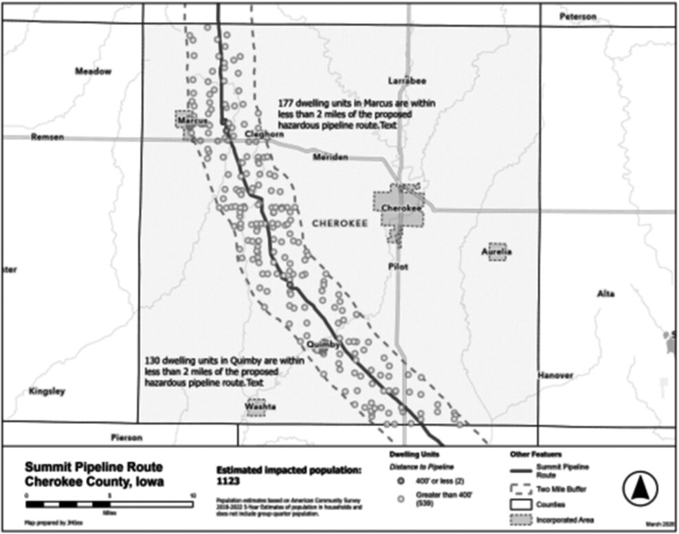
In Cherokee County, the towns of Quimby and Cleghorn fall entirely within the zone, along with parts of Marcus. Approximately 539 residences—home to an estimated 1,123 people—lie within two miles of the route.
It is estimated that 75% of the landowners along the 29.3 mile route in Cherokee county have signed voluntary easements. It is unclear how many of these landowners were advised of or knew of the risk such a pipeline poses.


Comments
No comments on this item Please log in to comment by clicking here